
Specifications


($GPGGA and $GPVTG) or
($GPGLL and $GPVTG).
Most GPS receivers can output the required sentences but most require configuring. You may need
to refer to your owners manual for the method.
Some Garmins have the capability of outputting the required information using the PVT format, this
is also supported by OziExplorer and this option is turned on in the Comm Tab in
Configuration
.
The GPS needs to be connected to the USB or serial port of the PC. Other GPS types, such as
bluetooth, use driver software to install a virtual serial port.
Starting Moving map
If you have everything setup correctly Moving Map can be started by selecting the
Start NMEA
Communication with the GPS
option on the Moving map Menu. Alternatively (and preferred) you
can activate the
Moving map Control
and press the Start button.
If it is working ok you should see some indication on the Status Line at the bottom of the map. See
the Status Display section below.
If it is not working as expected see the Trouble Shooting section in the Help Index.
Command Line Parameters
To allow moving map to be automatically started when starting OziExplorer the following command
line parameters are available. Note, the / is part of the parameter name.
The following command line parameters can be used when starting OziExplorer
/mmstart
- Starts Moving Map (NMEA) communication
/mmcontrol
-
Shows the Moving Map Control
/navcontrol
- Shows the Navigation Control
/gpsfix
- Shows the GPS Fix window
example command lines
oziexp.exe /mmstart /mmcontrol /navcontrol /gpsfix
oziexp.exe /mmstart
oziexp.exe c:\oziexplorer\maps\mymap.map /mmstart /mmcontrol
Note that you can specify a map on the command line but if the GPS position is not on that map or
the map has not been specified as available for Moving Map OziExplorer will attempt to find a new
map.
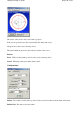
Status Display
The status line at the bottom of the screen displays the following.
The left hand panel will show "Moving Map is ON" when you start the NMEA communication. It
does not have to be receiving data from the GPS to display this message. The panel will show a <+>
symbol which will toggle on and off when actual data is being processed. If you see the plus sign it
means the correct data is being received and processed for display on the map, if you do not see the
<+> symbol something is not right. If the <+> symbol is not being toggled on and off data is not
Page
147
of
252
OziExplorer Help Contents