
Specifications


loaded and individual maps can then be deleted or added as required.
No Sort of Maps
- Does not automatically sort the maps, useful if you want to move the maps into a
specific order that will not change.
Sort Maps by Pixel Scale
- The maps at the top of the list are shown on top of the maps that are
lower in the list. Sorting the maps by their pixel scale is usually the best way as you would normally
want the higher detail maps on top.
Sort Maps by Name
- Sorts the maps by the map name.
Remove All maps from the List
- Removes all the maps from the seamless map list. This does not
affect the maps on disk it only removes them from this seamless map.
Delete All Map Thumbnails
- For seamless maps OziExplorer creates small thumbnails of various
sizes for each map to speed up the loading process. This option deletes the thumbnails and they will
be recreated as needed.
Configuration
-
Shows the configuration dialog.
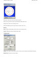
Configuration
Max Memory
(MBytes)
-
The amount of memory OziExplorer is to use for working with maps. The
default is 750 MBytes but much higher or lower values can be specified depending on the amount of
memory your PC has.
The Status Bar
Number Maps
-
the number of maps loaded
Mem Total for Maps
-
the total memory allocated in seamless maps configuration
Free for Maps
-
the amount of allocated memory remaining
Datums
What is a Datum?
The latitude and longitude of places on a chart or map depend on what mathematical shape is used to
represent the Earth when the chart or map is drawn. Different shapes get used for mapping different
areas of the world and these are known as ellipsoids. A datum references a particular
ellipsoid
known as the
reference ellipsoid
. Different datums can also have different origins and rotations. Both
these factors affect the numerical representation of a position.
Datums affect the positions of Latitude/Longitude and local grid systems (UTM, British National
Grid etc).
So how does this affect me?
If you have two charts of the same area and they have been drawn on different datums, then the
latitude and longitude for the same place is likely be different on each chart. In Australia the
Page
142
of
252
OziExplorer Help Contents