
Operation Manual


14
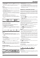
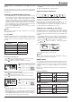
RAINFALL
Select display mode
The device displays how many mm / inches of rain are accumulated in
a one hour time period, based on current rainfall rate.
Press
button several times until the disered time range is displayed:
• RATE: Current rainfall rate in past an hour
• DAILY: Total rainfall from midnight
• WEEKLY: Total rainfall from the current week
• MONTHLY: Total rainfall from the current calendar month
Rainfall rate Daily rainfall Weekly rainfall Monthly rainfall
Fig. 26
NOTE!
Rain rate is updated every 6 minutes, at every hour on the hour, and at
6, 12, 18, 24, 30, 36, 42, 48, 54 minute past the hour.
Select rainfall measurement unit
1. Press and hold
button for 2 seconds to enter settings mode.
2. Use
or button to select mm (millimeter) or in (inch).
3. Press
button again to confirm and exit.
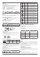
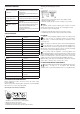
WIND SPEED / DIRECTION
Reading the wind direction
Wind direction indicator Meaning
Real-time wind direction
Wind directions appeared in last 5 minutes (max 6)
Fig. 27
Select display mode
Press
button several times until the desired rate is displayed:
• AVERAGE: average of all wind speed numbers recorded in the
previous 30 seconds
• GUST: highest wind speed (gust) recorded from last reading
Fig. 28
The wind level provides a quick reference on the wind condition and is
indicated by a series of text icons:
Wind level LIGHT MODERATE STRONG STORM
Speed 2-6 mph
3-13 km/h
9-25 mph
14-41 km/h
26-54 mph
42-87 km/h
≥ 55 mph
≥ 88 km/h
Select wind speed unit
1. Press and hold
button for 2 seconds to enter unit setting mode.
2. Use
or button to change the unit between mph (miles per
hour) / m/s (meter per second) / km/h (kilometer per hour) / knots.
3. Press
button to confirm and exit.
BEAUFORT SCALE
The Beaufort scale is an international scale of wind velocities from 0
(calm) to 12 (Hurricane force).
Beaufort-Nummer Beschreibung Geschwindigkeit
0
calm < 1 km/h | < 1 mph
< 1 knot | < 0.3 m/s
1
light
air
1.1-5.5 km/h | 1-3 mph
1-3 knot | 0.3-1.5 m/s
2
light
breeze
5.6-11 km/h | 4-7 mph
4-6 knot | 1.6-3.4 m/s
3
gentle
breeze
12-19 km/h | 8-12 mph
7-10 knot | 3.5-5.4 m/s
4
moderate
breeze
20-28 km/h | 13-17 mph
11-16 knot | 5.5-7.9 m/s
5
fresh
breeze
29-38 km/h | 18-24 mph
17-21 knot | 8.0-10.7 m/s
6
strong
breeze
39-49 km/h | 25-30 mph
22-27 knot | 10.8-13.8 m/s
7
high
wind
50-61 km/h | 31-38 mph
28-33 knot | 13.9-17.1 m/s
8
gale 62-74 km/h | 39-46 mph
34-40 knot | 17.2-20.7 m/s
9
strong
gale
75-88 km/h | 47-54 mph
41-47 knot | 20.8-24.4 m/s
10
Storm 89-102 km/h | 55-63 mph
48-55 knot | 24.5-28.4 m/s
11
violent
storm
103-117 km/h | 64-73 mph
56-63 knot | 28.5-32.6 m/s
12
Hurricane
force
≥ 118 km/h | ≥ 74 mph
≥ 64 knot | ≥ 32.7 m/s
WIND CHILL / HEAT INDEX / DEW-POINT
Reading wind chill
Press INDEX button several times until WIND CHILL is displayed.
Reading heat index
Press INDEX button several times until HEAT INDEX is displayed.
Heat index Warning Meaning
27° C - 32° C
(80° F - 90° F)
Caution Possibility of heat exhaustion
33° C - 40° C
(91° F - 105° F)
Extreme caution Possibility of dehydration
41° C - 54° C
(106° F - 129° F)
Danger Heat exhaustion likely
≥ 55° C
(≥ 130° F)
Extreme danger Strong risk of dehydration /
sun stroke
Reading dewpoint (indoor)
Press INDEX button several times until INDOOR DEWPOINT is
displayed.
NOTE!
The dew point is the temperature below which the water vapor in air at
constant barometric pressure condenses into liquid water at the same
rate at which it evaporates. The condensed water is called dew when
it forms on a solid surface.
The dewpoint temperature is calculated from the indoor temperature
and humidity measured at the main unit.
HISTORY DATA
(all records in the past 24 hours)
The main unit automatically records and displays data of the past 24
hours on the hour.
To check all the history data in the past 24 hours, press the HISTORY
button.
E.g. current time 7:25 a.m., Mach 28:
Press HISTORY button repeatedly to view past readings at 7:00am,