
User Guide
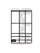


Table Of Contents
- 1. INTRODUCTION
- 2. GETTING STARTED
- 3. AVIATION MODE OPERATION
- BASIC OPERATION
- VFR MOVING MAP FUNCTION
- FLIGHT PLAN FUNCTION
- WEATHER FUNCTION
- HARDWARE ACCESSORY
- RECEIVING WEATHER DATA
- XM WEATHER INFORMATION PRODUCTS
- NEXRAD Composite Reflectivity (USA and Canada)
- Graphical METARs (USA and Canada)
- Graphical PIREPs (USA only)
- Graphical AIRMETs (USA only)
- Graphical SIGMETs (USA only)
- Graphical Conv-SIGMETs (USA only)
- Graphical Winds Aloft (USA only)
- Graphical Freezing Level
- Text METARs (USA and Canada)
- Text TAFs (USA and Canada)
- Text PIREPs (USA only)
- Text AIRMETs (USA only)
- Text SIGMETs (USA only)
- Text Conv-SIGMETs (USA only)
- Legend
- XM OVERLAYS
- TRAFFIC FUNCTION
- AUXILIARY FUNCTION
- SYSTEM SETUP FUNCTION
- 4. AUTOMOTIVE MODE OPERATION
- WARNINGS AND SAFETY INFORMATION
- GLOSSARY
- GETTING STARTED
- SIMPLE AND ADVANCED MODES
- SOFT KEYS AND CONTROLS ON THE SCREEN
- ADVANCED FUNCTIONS
- Smart Zoom
- Position Markers
- Current GPS Position and Lock-on-Road
- Returning to Normal Navigation
- Selected Location (Cursor)
- Original Position in the Cursor Menu
- Daytime and night color schemes
- Color scheme in tunnels
- Route Calculation and Recalculation
- Itinerary
- Track Logs
- Route demonstration
- POI (Points of Interest)
- Saving POI
- Managing POI
- Road Safety Cameras
- Saving Road Safety Cameras
- Camera Warning
- Camera Types
- Camera Directions
- Speed limit warning
- TMC (Traffic Message Channel)
- ADVANCED FEATURES IN GODRIVE VERSION 8.3
- SELECTING THE DESTINATION OF A ROUTE
- Selecting the Cursor as the destination
- Entering an address or part of an address
- Entering an Address (Europe)
- Entering an Address (North America, Australia)
- Entering an Address if house numbering is restarted
- Enter an Address without knowing the district/suburb
- Selecting an Intersection as the Destination
- Selecting a City Center as the Destination
- Entering an Address with a Postal Code
- Tips on Entering Addresses Quickly
- Selecting the destination from your Favorites
- Selecting the destination from the POIs
- Selecting the destination with saved POI search criteria
- Selecting the destination from the History
- Selecting the destination by entering its coordinate
- CREATING A MULTI-POINT ROUTE (INSERTING A VIA POINT)
- CREATING A MULTI-POINT ROUTE (APPEND A NEW DESTINATION)
- EDITING THE ROUTE
- VIEWING WHOLE ROUTE ON THE MAP (FIT TO SCREEN)
- WATCHING THE SIMULATION OF THE ROUTE
- ENABLING SAFETY MODE
- PAUSING THE ACTIVE ROUTE
- DELETING THE NEXT VIA POINT FROM THE ROUTE
- DELETING THE ACTIVE ROUTE
- USING TRACK LOGS
- SELECTING THE DESTINATION OF A ROUTE
- REFERENCE BOOK (ADVANCED MODE)
- 5. MULTIMEDIA
- 6. SYSTEM SETTINGS
- 7. APPENDIX

AV8OR Ace User’s Guide Automotive Mode Operation
Pub. No D200904000003 Page 4-87 Rev 1 Jul 2009
© Honeywell International Inc. Do not copy without express permission of
Honeywell.
Name Description Function
Arrival Time Shows the
estimated arrival
time at the final
destination of the
route based on
information
available for the
remaining
segments of the
route. The
calculation cannot
take into account
traffic jams and
other possible
delays.
Tap this field to
show it on the map
screen in one of the
Trip Data fields.
GPS Time Shows the current
time corrected
with time zone
offset. The
accurate time
comes from the
GPS satellites,
and the time zone
information comes
from the map or it
can be set
manually in
Regional settings.
Tap this field to
show it on the map
screen in one of the
Trip Data fields.
Altitude Shows the
elevation if it is
provided by the
GPS receiver.
Tap this field to
show it on the map
screen in one of the
Trip Data fields.
Speed Limit Shows the speed
limit of the current
street if the map
contains it.
Tap this field to
show it on the map
screen in one of the
Trip Data fields.
Opens a new
screen with three
resettable Trip
Computers.