
User Guide


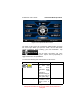
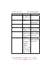
Table Of Contents
- 1. INTRODUCTION
- 2. GETTING STARTED
- 3. AVIATION MODE OPERATION
- BASIC OPERATION
- VFR MOVING MAP FUNCTION
- FLIGHT PLAN FUNCTION
- WEATHER FUNCTION
- HARDWARE ACCESSORY
- RECEIVING WEATHER DATA
- XM WEATHER INFORMATION PRODUCTS
- NEXRAD Composite Reflectivity (USA and Canada)
- Graphical METARs (USA and Canada)
- Graphical PIREPs (USA only)
- Graphical AIRMETs (USA only)
- Graphical SIGMETs (USA only)
- Graphical Conv-SIGMETs (USA only)
- Graphical Winds Aloft (USA only)
- Graphical Freezing Level
- Text METARs (USA and Canada)
- Text TAFs (USA and Canada)
- Text PIREPs (USA only)
- Text AIRMETs (USA only)
- Text SIGMETs (USA only)
- Text Conv-SIGMETs (USA only)
- Legend
- XM OVERLAYS
- TRAFFIC FUNCTION
- AUXILIARY FUNCTION
- SYSTEM SETUP FUNCTION
- 4. AUTOMOTIVE MODE OPERATION
- WARNINGS AND SAFETY INFORMATION
- GLOSSARY
- GETTING STARTED
- SIMPLE AND ADVANCED MODES
- SOFT KEYS AND CONTROLS ON THE SCREEN
- ADVANCED FUNCTIONS
- Smart Zoom
- Position Markers
- Current GPS Position and Lock-on-Road
- Returning to Normal Navigation
- Selected Location (Cursor)
- Original Position in the Cursor Menu
- Daytime and night color schemes
- Color scheme in tunnels
- Route Calculation and Recalculation
- Itinerary
- Track Logs
- Route demonstration
- POI (Points of Interest)
- Saving POI
- Managing POI
- Road Safety Cameras
- Saving Road Safety Cameras
- Camera Warning
- Camera Types
- Camera Directions
- Speed limit warning
- TMC (Traffic Message Channel)
- ADVANCED FEATURES IN GODRIVE VERSION 8.3
- SELECTING THE DESTINATION OF A ROUTE
- Selecting the Cursor as the destination
- Entering an address or part of an address
- Entering an Address (Europe)
- Entering an Address (North America, Australia)
- Entering an Address if house numbering is restarted
- Enter an Address without knowing the district/suburb
- Selecting an Intersection as the Destination
- Selecting a City Center as the Destination
- Entering an Address with a Postal Code
- Tips on Entering Addresses Quickly
- Selecting the destination from your Favorites
- Selecting the destination from the POIs
- Selecting the destination with saved POI search criteria
- Selecting the destination from the History
- Selecting the destination by entering its coordinate
- CREATING A MULTI-POINT ROUTE (INSERTING A VIA POINT)
- CREATING A MULTI-POINT ROUTE (APPEND A NEW DESTINATION)
- EDITING THE ROUTE
- VIEWING WHOLE ROUTE ON THE MAP (FIT TO SCREEN)
- WATCHING THE SIMULATION OF THE ROUTE
- ENABLING SAFETY MODE
- PAUSING THE ACTIVE ROUTE
- DELETING THE NEXT VIA POINT FROM THE ROUTE
- DELETING THE ACTIVE ROUTE
- USING TRACK LOGS
- SELECTING THE DESTINATION OF A ROUTE
- REFERENCE BOOK (ADVANCED MODE)
- 5. MULTIMEDIA
- 6. SYSTEM SETTINGS
- 7. APPENDIX

AV8OR Ace User’s Guide Automotive Mode Operation
Pub. No D200904000003 Page 4-77 Rev 1 Jul 2009
© Honeywell International Inc. Do not copy without express permission of
Honeywell.
Symbol Name Description
via points as you want.
Destination
(end point)
The last point of the route, the final
destination.
Symbol Name Description
Route color The route always stands out with its color
on the map, both in daytime and in night
color mode. The active leg of the route is
always displayed in a brighter shade than
the inactive (upcoming) legs.
Active leg of
the route
The section of the route on which you are
driving. If you have not added any via
points (only a destination), the entire
route is the active leg. If you have added
via points, the active leg is the part of the
route from your current location to the
next route point (the next via point, or the
destination if there are no more via points
to reach).
Inactive legs
of the route
The future sections of the route; each of
them becomes active when you reach
the via point at its beginning.
Streets and
roads that are
excluded from
the navigation
You can choose whether you want to use
or avoid certain road types. However,
when GoDrive cannot avoid such roads,
the route will include them and it will
show them in a color that is different from
the route color.
Detour menu
This screen contains quick detour possibilities during navigation. It
can be opened directly from the Map screen by tapping .
You have the following options: