
User Guide


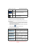


Table Of Contents
- 1. INTRODUCTION
- 2. GETTING STARTED
- 3. AVIATION MODE OPERATION
- BASIC OPERATION
- VFR MOVING MAP FUNCTION
- FLIGHT PLAN FUNCTION
- WEATHER FUNCTION
- HARDWARE ACCESSORY
- RECEIVING WEATHER DATA
- XM WEATHER INFORMATION PRODUCTS
- NEXRAD Composite Reflectivity (USA and Canada)
- Graphical METARs (USA and Canada)
- Graphical PIREPs (USA only)
- Graphical AIRMETs (USA only)
- Graphical SIGMETs (USA only)
- Graphical Conv-SIGMETs (USA only)
- Graphical Winds Aloft (USA only)
- Graphical Freezing Level
- Text METARs (USA and Canada)
- Text TAFs (USA and Canada)
- Text PIREPs (USA only)
- Text AIRMETs (USA only)
- Text SIGMETs (USA only)
- Text Conv-SIGMETs (USA only)
- Legend
- XM OVERLAYS
- TRAFFIC FUNCTION
- AUXILIARY FUNCTION
- SYSTEM SETUP FUNCTION
- 4. AUTOMOTIVE MODE OPERATION
- WARNINGS AND SAFETY INFORMATION
- GLOSSARY
- GETTING STARTED
- SIMPLE AND ADVANCED MODES
- SOFT KEYS AND CONTROLS ON THE SCREEN
- ADVANCED FUNCTIONS
- Smart Zoom
- Position Markers
- Current GPS Position and Lock-on-Road
- Returning to Normal Navigation
- Selected Location (Cursor)
- Original Position in the Cursor Menu
- Daytime and night color schemes
- Color scheme in tunnels
- Route Calculation and Recalculation
- Itinerary
- Track Logs
- Route demonstration
- POI (Points of Interest)
- Saving POI
- Managing POI
- Road Safety Cameras
- Saving Road Safety Cameras
- Camera Warning
- Camera Types
- Camera Directions
- Speed limit warning
- TMC (Traffic Message Channel)
- ADVANCED FEATURES IN GODRIVE VERSION 8.3
- SELECTING THE DESTINATION OF A ROUTE
- Selecting the Cursor as the destination
- Entering an address or part of an address
- Entering an Address (Europe)
- Entering an Address (North America, Australia)
- Entering an Address if house numbering is restarted
- Enter an Address without knowing the district/suburb
- Selecting an Intersection as the Destination
- Selecting a City Center as the Destination
- Entering an Address with a Postal Code
- Tips on Entering Addresses Quickly
- Selecting the destination from your Favorites
- Selecting the destination from the POIs
- Selecting the destination with saved POI search criteria
- Selecting the destination from the History
- Selecting the destination by entering its coordinate
- CREATING A MULTI-POINT ROUTE (INSERTING A VIA POINT)
- CREATING A MULTI-POINT ROUTE (APPEND A NEW DESTINATION)
- EDITING THE ROUTE
- VIEWING WHOLE ROUTE ON THE MAP (FIT TO SCREEN)
- WATCHING THE SIMULATION OF THE ROUTE
- ENABLING SAFETY MODE
- PAUSING THE ACTIVE ROUTE
- DELETING THE NEXT VIA POINT FROM THE ROUTE
- DELETING THE ACTIVE ROUTE
- USING TRACK LOGS
- SELECTING THE DESTINATION OF A ROUTE
- REFERENCE BOOK (ADVANCED MODE)
- 5. MULTIMEDIA
- 6. SYSTEM SETTINGS
- 7. APPENDIX

AV8OR Ace User’s Guide Automotive Mode Operation
Pub. No D200904000003 Page 4-18 Rev 1 Jul 2009
© Honeywell International Inc. Do not copy without express permission of
Honeywell.
The following area appears next to the above described rounded
area. When tapping this area, the result depends on the information
currently shown.
Icon Information Details Action
There is no
valid GPS
position
If there is no
valid GPS
position, this
symbol
appears here.
Tap this area
to open the
GPS Data
screen to
check the
signal status or
the connection
settings.
Traffic
restriction
When GPS
position is
available, but
there is no
route to be
navigated, the
traffic
restriction of
the upcoming
intersection is
shown here if
there is any
Nothing
happens if you
tap this area of
the screen.
,
Second route
event
(maneuver
after the next
maneuver)
When GPS
position and an
active route are
both available,
this field shows
the route event
that follows the
next route
event shown in
the above
described area.
Tap this area
to open the
Itinerary
screen with the
turn by turn
guidance
instructions.
Approaching
a Road
Safety
Camera
This icon
appears when
you are
approaching a
Road Safety
Tap this area
to suppress
the audible
camera
warning.