
GPS Receiver User Manual


Basic GPS Operation
3-46
Effective Date 5/95 006-08791-0000 Rev 0
Basic GPS Operation
Chapter 3
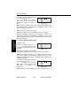
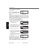
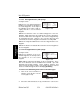
If the airport is being viewed as part of
the
nearest airports list
(see section
3.8.1, “Viewing the Nearest
Waypoints”), the APT 1 page format
will differ as follows (see figure 3-
134):
Line 1:After the airport identifier, the number designating the air-
port’s position in the nearest airport list is displayed. In figure 3-134,
KLIT is the third nearest airport.
Line 2:Same as a normal APT 1 page.
Line 3:The length, surface, and lighting of the longest runway.
Line 4:The magnetic bearing to or the magnetic radial from the
airport and the distance in nautical miles. Placing the cursor over the
radial/bearing field and pressing Etoggles between radial from and
bearing to the airport.
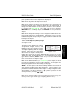
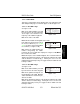
3.11.1.2. The Airport 2 (APT 2) Page
See figure 3-135.
Line 1:The ICAO identifier (see
section 2.3) of the airport; an arrow
precedes the identifier if it is the active
waypoint.
Lines 2-3:The latitude and longitude
of the airport reference point (the “official” location of the airport).
Line 4:The magnetic bearing to or the magnetic radial from the air-
port and the distance in nautical miles. Placing the cursor over the
radial/bearing field and pressing Etoggles between radial from and
bearing to the airport.
If the airport is being viewed as part of
the
nearest airports list
(see section
3.8.1, “Viewing the Nearest
Waypoints”), the APT 2 page format
will differ as follows (see
figure 3-136):
Line 1:After the airport identifier, the number designating the air-
APT VOR NDB SUP ACT NAV FPL CAL SET OTH
åå.ånm KLIT 3
åååååå LITTLE ROCK
>Leg AR
APT 2 >103°To 14.5nm
Figure 3-136
APT VOR NDB SUP ACT NAV FPL CAL SET OTH
åå.ånm KLIT 3 260ft
åååååå ADAMS
>Leg 7200ft HRD L
APT 1 >103°To 14.5nm
Figure 3-134
APT VOR NDB SUP ACT NAV FPL CAL SET OTH
åå.ånm KLIT
åååååå N 34°43.74'
>Leg W 92°13.47'
APT 2 >103°To 14.5nm
Figure 3-135