
GPS Receiver User Manual

KLN 35A Pilot’s Guide Basic GPS Operation
3-45
Effective Date 5/95006-08791-0000 Rev 0
Basic GPS Operation
Chapter 3
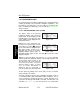
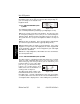
•Press Eto instantly declutter the SUA, VOR, and airport
selections from the graphics display. Flight plan and Direct To
waypoints will still be displayed. Press Eagain to restore the
selections.
CAUTION: The NAV 4 page does not display weather, terrain, or
other data.
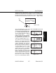
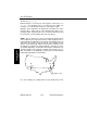
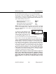
3.11. WAYPOINT PAGES
NOTE: Each of the waypoint page types includes a cyclic field which
displays present magnetic bearing to or magnetic radial from the
waypoint. Due to “great circle” courses and magnetic variation
differences between present position and the active waypoint, the To
bearing and From radial may not be exactly 180° different from each
other. This condition is most likely to occur when long distances are
involved, and/or you are operating in very northerly or southerly
latitudes. See section 3.10.1 and figure 3-114 for more details.
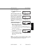
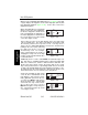
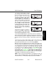
3.11.1. AIRPORT PAGES
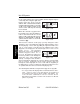
3.11.1.1. The Airport 1 (APT 1) Page
See figure 3-132.
Line 1:The ICAO identifier (see
section 2.3) of the airport; an arrow
precedes the identifier if it is the
active waypoint. The airport elevation
above MSL in feet, which is rounded
to the nearest 10 feet.
Line 2:The name of the airport.
Line 3:The city where the airport is located.
Line 4:The State if the airport is
located in the U.S., the Province if
located in Canada, or the country if
outside the U.S. and Canada. A list-
ing of the abbreviations used for
States, Provinces, and countries is
contained in Appendix D. The right
side of line 4 will read MILITARYif it
is a military airport (Figure 3-133) or PRIVATEif it is a private-use
airport.
APT VOR NDB SUP ACT NAV FPL CAL SET OTH
åå.ånm KSZL 870ft
åååååå WHITEMAN AFB
>Leg KNOB NOSTER
APT 1 MO MILITARY
Figure 3-133
APT VOR NDB SUP ACT NAV FPL CAL SET OTH
åå.ånm KLIT 260ft
åååååå ADAMS
>Leg LITTLE ROCK
APT 1 AR
Figure 3-132