
Operating instructions
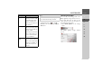
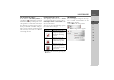
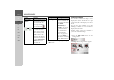
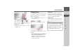
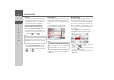
Table Of Contents
- Index
- Safety information
- The Navigation device
- OVERVIEW OF SCOPE OF SUPPLY
- OVERVIEW OF NAVIGATION DEVICE
- General operation
- Maintenance and care
- Battery quality declaration
- Display quality declaration
- Start-up
- Power supply
- TMC antenna (depending on the model)
- GPS-antenna
- Cable for vehicle integration (depending on the model, optional)
- Memory card
- Unit bracket
- Switching the Navigation device on/off
- Basic information about the touch screen
- Basic information about the menus
- Radio remote control
- Content Manager
- Transferring music tracks, pictures and videos
- Faults
- Navigation mode
- What is navigation?
- Selecting navigation
- Last destinations list
- The New or New Destination Menu (depending on device)
- Navigation settings
- Traffic announcements using TMC (depending on the model)
- The map display
- Calling up the map display
- Structure of the map display
- Using the map display
- Map display options
- Point of interest on the route
- TMC on the route (depending on the model)
- Cancel route guidance
- Changing route options
- Block route
- Switching the map mode
- Changing the map orientation
- Route calculator (depending on the model)
- Setting day/night display
- Selecting/setting the vehicle profile
- Entering a destination
- Enter/delete waypoint
- Displaying the entire route
- Displaying the destination list
- Skipping destination
- Displaying current position
- Saving a position
- Calling up the telephone (depending on the model)
- Switching off the display
- Defining fast access buttons
- TELEPHONE MODE
- Extras
- Settings
- Specialist words
- Keywords
- MODEL OVERVIEW AND TECHNICAL SPECIFICATIONS
- NOTICE

66
>>> NAVIGATION MODE
> D
> GB
> F
> I
> E
> PL
> CZ
> H
> RU
The following setting options are available
in the extended settings:
•
Auto zoom
You can select how the map changes
when approaching an action point or at
different speed.
•
Select POI categories
You can select which symbols are dis-
played for points of interest on the map.
•
Street names 2D/Street names 3D
You can select whether the street names
should be displayed ( ) or not ( ) in
3D or 2D mode.
•
2D heading up
You can select whether the map should
always be orientated to the direction of
travel ( ) or to the north ( ) in 2D
mode.
Autozoom
> Press the
Auto zoom button in the ex-
tended settings.
Pressing the
Auto zoom button switches
the zoom function on ( ) or off ( ).
When the zoom function is switched on,
you can select whether the autozoom ac-
tion should be weak, medium or strong.
Setting POI categories
You can select which POI symbols are to
be displayed on the map.
> Press the
Select POI categories button
in the extended settings.
Selecting
Show all POIs displays all points
of interest on the map.
Selecting
Show no POIs displays no
points of interest on the map.
Selecting
User defined selection and
then pressing the
Select POIs button al-
lows you to determine for yourself in the
menu which then appears whether each
individual points of interest category is
displayed or not.
*Function can be retrofitted