
Operating instructions
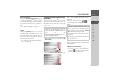
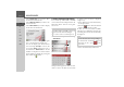
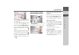
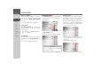
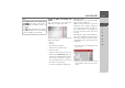
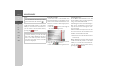
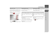
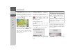
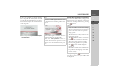
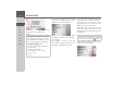
Table Of Contents
- Index
- Safety information
- The Navigation device
- OVERVIEW OF SCOPE OF SUPPLY
- OVERVIEW OF NAVIGATION DEVICE
- General operation
- Maintenance and care
- Battery quality declaration
- Display quality declaration
- Start-up
- Power supply
- TMC antenna (depending on the model)
- GPS-antenna
- Cable for vehicle integration (depending on the model, optional)
- Memory card
- Unit bracket
- Switching the Navigation device on/off
- Basic information about the touch screen
- Basic information about the menus
- Radio remote control
- Content Manager
- Transferring music tracks, pictures and videos
- Faults
- Navigation mode
- What is navigation?
- Selecting navigation
- Last destinations list
- The New or New Destination Menu (depending on device)
- Navigation settings
- Traffic announcements using TMC (depending on the model)
- The map display
- Calling up the map display
- Structure of the map display
- Using the map display
- Map display options
- Point of interest on the route
- TMC on the route (depending on the model)
- Cancel route guidance
- Changing route options
- Block route
- Switching the map mode
- Changing the map orientation
- Route calculator (depending on the model)
- Setting day/night display
- Selecting/setting the vehicle profile
- Entering a destination
- Enter/delete waypoint
- Displaying the entire route
- Displaying the destination list
- Skipping destination
- Displaying current position
- Saving a position
- Calling up the telephone (depending on the model)
- Switching off the display
- Defining fast access buttons
- TELEPHONE MODE
- Extras
- Settings
- Specialist words
- Keywords
- MODEL OVERVIEW AND TECHNICAL SPECIFICATIONS
- NOTICE

48
>>> NAVIGATION MODE
> D
> GB
> F
> I
> E
> PL
> CZ
> H
> RU
Displaying the route
Once the address has been entered, the ad-
dress input menu allows the route to the
destination to be displayed on the map.
> Press the
Show route button to display
the route on the map.
The route is calculated.
You can start the route guidance directly
from this screen using the
Start button.
The other options on this screen are de-
scribed under “Displaying the entire
route” on page 93.
Storing a destination
In the address input menu, the
Save but-
ton opens a menu where a name can be
entered for the specified destination.
If the desired name has been entered and
has been pressed to accept it, the
destination is transferred to fast access
mode and protected.
Starting navigation (trace)
The
Start button starts the route
guidance.
All data entered thus far is processed when
calculating the route.
> Press
Start to start the route guidance.
The route is calculated. The map will then
be displayed and the route guidance will
begin.
If the route guidance is already running
you will be asked whether the new desti-
nation should replace the old destination
or if the new destination should be regard-
ed as a waypoint.
> Select
Add as stopover or Replace old
destination
.
Note:
The symbols above the progress bar refer
to restrictions that you may have acti-
vated (e. g. unpaved roads, toll roads).
The symbol next to the progress bar
indicates that the time-dependent route
guidance described in “The Route
options button” on page 61 is active.
(depending on the model)