
Operating instructions
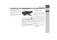
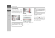

Table Of Contents
- Index
- Safety information
- The Navigation device
- OVERVIEW OF SCOPE OF SUPPLY
- OVERVIEW OF NAVIGATION DEVICE
- General operation
- Maintenance and care
- Battery quality declaration
- Display quality declaration
- Start-up
- Power supply
- TMC antenna (depending on the model)
- GPS-antenna
- Cable for vehicle integration (depending on the model, optional)
- Memory card
- Unit bracket
- Switching the Navigation device on/off
- Basic information about the touch screen
- Basic information about the menus
- Radio remote control
- Content Manager
- Transferring music tracks, pictures and videos
- Faults
- Navigation mode
- What is navigation?
- Selecting navigation
- Last destinations list
- The New or New Destination Menu (depending on device)
- Navigation settings
- Traffic announcements using TMC (depending on the model)
- The map display
- Calling up the map display
- Structure of the map display
- Using the map display
- Map display options
- Point of interest on the route
- TMC on the route (depending on the model)
- Cancel route guidance
- Changing route options
- Block route
- Switching the map mode
- Changing the map orientation
- Route calculator (depending on the model)
- Setting day/night display
- Selecting/setting the vehicle profile
- Entering a destination
- Enter/delete waypoint
- Displaying the entire route
- Displaying the destination list
- Skipping destination
- Displaying current position
- Saving a position
- Calling up the telephone (depending on the model)
- Switching off the display
- Defining fast access buttons
- TELEPHONE MODE
- Extras
- Settings
- Specialist words
- Keywords
- MODEL OVERVIEW AND TECHNICAL SPECIFICATIONS
- NOTICE

37
NAVIGATION MODE >>>
> D
> GB
> F
> I
> E
> PL
> CZ
> H
> RU
Navigation mode
What is navigation?
The term "navigation" (lat. navigare = to
travel by sea) is generally understood to
mean the location of a vehicle, the deter-
mination of the direction and distance
from the desired destination and the de-
termination of the required route. Stars,
prominent landmarks, compass and satel-
lites etc. are used as navigation aids.
With the Navigation device, the location
is determined by the GPS receiver. The
Global Positioning System (GPS) was de-
veloped during the 1970s by the US mili-
tary as a weapons guiding system.
GPS is based on a total of 24 satellites or-
biting the Earth and emitting signals. A
GPS receiver receives these signals and
uses the signal times to calculate the dis-
tance to an individual satellite, and then
determines your current geographical po-
sition.
Signals from at least three satellites are re-
quired to determine your position; your
height above sea level can be calculated if
signals are received from four or more sat-
ellites.
The Navigation device determines the di-
rection and distance from the destination
using a navigation computer and a digital
street map held in its internal memory.
For safety reasons, route guidance is given
predominantly in spoken form. This is
supported by a direction indicator and a
map display on the touch screen.
¤Safety instructions
• Road traffic regulations always take
priority. The navigation system is only
an aid. Errors may occur in individual
data items/entries. At all times, the
driver must decide whether or not to
heed the information provided.
We do not accept liability for errone-
ous data provided by the navigation
system.
• When first put into use it can take up
to 30 minutes to fix the position.
• Observation of traffic signs and local
traffic regulations must always take pri-
ority.
• Traffic guidance is restricted to passen-
ger vehicles. Special driving recom-
mendations and regulations for other
vehicles (e.g. commercial vehicles) are
not included.
• Destinations may only be entered
when the vehicle is stationary.