
Hardware Solutions for Gas Utilities Manual

4. Select OK.
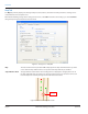
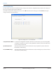
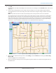
Result: In Map View, the map control display on the left side of the screen changes to show "GPS OK" and the vehicle speed
(Figure 49).
5. Drive the route slowly (between 5 and 10 mph). As meter readings are received, the software logs the latitude
and longitude values of each meter reading. The location values for the strongest reading received for each meter
are stored.
OTE:N If you drive faster than 15 mph, the speed display turns red and you will hear the siren. Slow down.
As you slowly drive the route and a meter reading comes in that requires a location, you will hear a sound and the
map display will show a new green circle for the meter that was just read. Each time you receive a meter reading
from a meter that requires a location, you will hear the sound and see another green circle. In the background, the
software is fine tuning the location information for meters that require locations when a stronger meter reading
transmission is received. However, you will not hear or see anything while that is happening.
Figure 49: Meter reading in geocoding mode
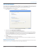
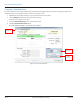
6. When you have completed storing locations, select Settings, select the General tab and change the Geocoding
Mode to OFF.
Result: The display returns to normal operation.
7. When you unload the readings into the reading data management software, the latitude and longitude values are
unloaded as well.
GEOCODING METER LOCATIONS
Page 49 April 2014 ORION® Meter Reading System (ORS)