
Hardware Solutions for Gas Utilities Manual

Map Tab
The Map tab primarily displays the settings for map location, features, orientation and entry/exit zones. Settings can be
customized based on user preferences.
When finished making changes to the settings on this screen, select OK and return to the reading cycle. Select Cancel to
disregard any changes and return to the main menu.
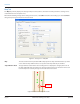
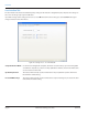
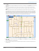
Figure 43: Settings screen - Map tab
Map The state name for the map loaded in ORS is displayed in the drop-down field at the top of the
screen. Click the drop-down menu to see any other state maps that may be available.
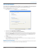
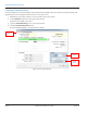
Snap Vehicle To Road The approximate location of the meter reading vehicle is displayed as a bright yellow icon on
the map (Figure 44) when geocoding is on. Checking this box “snaps” or moves the vehicle icon
to the most precise location, placing it on the road nearest its location.
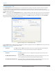
Figure 44: Vehicle icon “snapped” to road
Vehicle on
the road
SETTINGS
Page 42 April 2014ORION® Meter Reading System (ORS)