
Hardware Solutions for Gas Utilities Manual
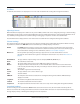

Map Control
The Map control buttons are located on the right and left sides of the display when Map View is selected from the main
tool bar.
Figure 23: Map buttons left side Figure 24: Map buttons right side
Left Side Buttons
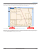
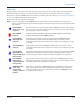
Legend Toggles between the distance legend and the icon legend. The distance legend displays on the map
and defines the distance to which the map is scaled, inches per foot (Figure 25). The icon legend gives
a description for the meter icons that display on the map. The icon legend has a dynamic display that
changes based on the meter type(s) loaded in the route file. To see the icons and their descriptions, refer to
"Meter Icons" on page 25.
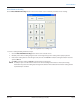
Find Address Click this button to enter a specific address in the window that appears. Click OK when finished and the
map centers itself to the address entered.
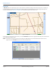
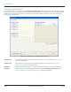
Show All
Services
To display the location information of all available meters, click the Show All Services button. This button
centers all the meters and displays location information on the map.
Figure 25: Distance legend
Right Side Buttons
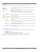
Select Meter Allows you to click a meter icon to display the meter details. If two or more meters are in the same place, a
list with all the available meters in that location is displayed.
Recenter Pauses reading and allows you to move the map in any direction. Click, hold and drag the map to the
location you desire. Then click the Start icon in the main tool bar to resume meter reading.
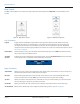
Zoom In Allows you to draw a box around an area and zoom into it. If you click this button, you can zoom into the
map by centering the map on the spot that you selected.
Zoom Out Allows you to zoom out of the current map area using the selected point as the center of the map.
Zoom Default Returns to the default map view. To adjust the default setting, refer to "Map Tab" on page 42.
READING A ROUTE
Page 24 April 2014ORION® Meter Reading System (ORS)