
Manual
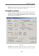


General Layers
3.29
with wind, tide and tacking angle.
shoreline Deckman can provide a simple shoreline if chart
coverage for a particular area is poor.
digital chart allows you to see present position against a
chart—almost always left on.
North displays a north arrow in the top left hand
corner of the screen.
Wind shows a tuft of wind arrows at intervals along
the boat's track. The direction of the arrows
indicates the true wind direction and their
lengths indicate true wind speed. Note that the
lines point into the wind.
DR track shows the track of the boat calculated from
Dead Reckoning, not including the current.
PF track shows the track of the boat given by the position
fixing system, usually GPS.
Course marks displays the waypoints that are a part of the
course that fall within the geographical
boundaries of the window.
other marks displays in the window every mark in the
waypoint file that comes within the
geographical boundaries of the window’s
display.
GRIB view ignore this setting (it should remain turned on).
Please see page 9.1 for details of operation of
the GRIB viewer feature.
boat shows the present position of the boat.
join
waypoints
connects waypoints for present route by a great
circle
isochrones gives you the option of having the toolbar icons
for Planning displayed at the top of the
Navigation screen. Most useful if left on, but
turn off to remove isochrones when you have
finished using Planning.