
Manual

Tides
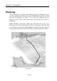
3.21
Figure 3.12
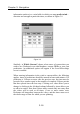
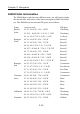
To edit a waypoint—either name, short name, latitude or longitude—
simply click in the box where you wish to make the change and then use
the computer's keyboard. To enter a new waypoint click in the left hand
column (the cursor will change to an arrow) on the row where you want
to insert the new waypoint and then click
new
from the bottom left of
the window. A new waypoint with the name 't' will be created; edit name
or position as above. Names and positions can also be cut and pasted in
the same way.
Note.
Positions are in the form: degrees, minutes and decimals of
minutes. As always, positive values are North and East; negative are
South and West.
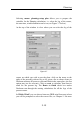
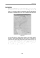
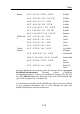
Tides
To use the tidal facility in an area that Deckman’s tidal information
covers, you have to enter the high water times and heights for the ports
near to the area you are sailing in.
Select
menu>planning>edit HW
and the dialog shown in Figure
3.12 will appear.
Put the date of the first high water
you enter in the
date
box. To
enter times and heights click over
the value you wish to change and
use the computer's keyboard (not
the numeric keypad here). To
insert additional entries, either
between or after those already
there, click in the left hand
column (headed
HW ,
where you
will see the cursor change to an
arrow) at the position you wish to
make the entry and then choose
new
. You can also cut and paste the entries by selecting them in the LH
column.