
User Manual


Aeronautical Navigator AvMap EKPV
4 - Quick Manual
Aeronautical Navigator AvMap EKPV
Quick Manual - 5
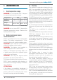
1. LEARN BEFORE USE
I. Safe temperature range
DANGER: do not operate EKP V beyond
the operating temperature range.
DANGER: do not store EKP V beyond the
Storage temperature range. Remove the
battery before storage.
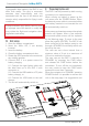
II. Battery and power source
recommendations
EKP V is provided with a Li-Ion rechargeable
battery. The battery compartment is in the
back side of the unit, under the battery cover.
DANGER: Never operate or store EKP V
without the battery cover in place.
DANGER: The battery could explode in
case of improper use or short-circuit.
Battery is recharged connecting EKP V to
a power source using the cigarette lighter
cable or the wall charger.
DANGER: Use only the original cables
provided in the box to power EKP V.
Full charge of battery requires about 6 hours.
EKP V can be operative while charging; in
this case the full charge of battery could take
up to 12 hours.
ATTENTION:
If the battery is completely discharged, it
could be necessary to remove it and then to
power up the unit on external power. Once
the unit is running re-insert the battery.
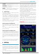
III. Warning
The electronic cartography displayed by the
EKP V is not certied for use for VFR or IFR
ights. The EKP aeronautical GPS navigator
is meant as an aid to VFR navigation and is
not a substitute for ofcial PUBLICATIONS,
NOTAM, BRIEFINGS and AERONAUTICAL
CHARTS that must be in any case carefully
consulted before and during any ight.
The information provided by the EKP is GPS
based information which is only intended to
supplement ofcial charts.
All critical ight information is presented for
reference only and must be veried by the
user.
The EKP is not a substitute for on-board
instruments.
The sector MORA values provide a minimum
1000 foot clearance above terrain and
physical obstructions.
Terrain and obstacle data provided are only
to be used as a general reference to your
surroundings and as an aid for situational
awareness.
Street network information has only been
provided with the purpose of reference during
ight and should be used with caution.
The altitude shown by EKP V is the geometric
distance from the sea level based on GPS
data.
XM Weather data is meant to show
atmospheric disturbances in order to select
alternative routes, and not to guide you
through the bad weather conditions.
The Global Positioning System (GPS) is
a space-based global navigation satellite
system operated by the U.S. Government,
which is solely responsible for its accuracy
and maintenance.
EKP V has an internal data logger where
the ight data is recorded. Data logger is not
accessible without disassembling the unit.
EKP V chart and database data are provided
by third parties, included but not limited to
Navteq® and Jeppesen®.
Temperature MIN MAX
Operating
temperature
- 20° C / - 4° F 60° C / - 140° F
Storage
temperature*
- 30° C / - 22° F 80° C / - 176° F
*without battery