
User manual

19
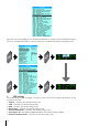
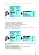
at the top or bottom of the Moving Map, depending on the cursor location. In the image above,
the cursor is in the Rockies and the approximate elevation is reported to be 9,252 feet. The shading
will only be visible with Terrain On.
2. TAWS (Terrain Awareness Warning System)
TAWS is a very powerful feature that uses the separation between the aircraft and the land
elevation to highlight the dangerous land elevations, allowing the map to be more easily and
readily interpreted. As seen in Section E.1 on page 19, there are 3 TAWS settings: Auto, Low SEP
(Separation) and High SEP (Separation).
The color shading is based on the Obstacle Clearance Height (OCH) calculation performed by the
EKP-IV. The OCH is the difference between the altitude of the plane and the current land elevation.
Set to HIGH SEP, TAWS will highlight all terrain with an OCH value under 1000 feet in red, while
a LOW SEP will highlight all terrain with an OCH value under 500 feet.
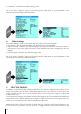
HIGH SEP LOW SEP
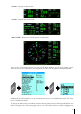
Once TAWS is active with a position fix, there will be a small box in the lower left hand corner of
the Moving Map:
The red, yellow and green colors correspond to the Obstacle Clearance Height (OCH) at any
given location. The OCH is calculated by subtracting the current elevation from your altitude. The
shading varies in both the Highland and Lowland definitions accordingly:
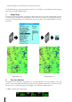
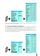
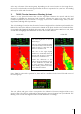
The same Flight Plan is used in
both images.
The one on the left depicts TAWS
set to HIGH SEP, where all terrain
with an OCH of 1000 feet and
below is shaded in red.
The one on the right depicts
TAWS set to LOW SEP, where all
terrain with an OCH of 500 feet
and below is shaded in red.
Notice the difference in the
yellow and green shading as well,
as the threshold on LOW SEP
is much narrower, allowing for
more shading. Please refer to the
color definitions below.