
User manual

18
E. TERRAIN AND TAWS
The EKP-IV contains a detailed topographic map on the CF card that helps provide improved
situational awareness. Additionally, the EKP-IV now features a Terrain Awareness Warning System
(TAWS) that further highlights safe and unsafe elevation for an easier to read map display.
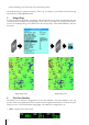
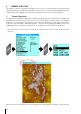
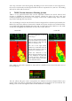
1. Terrain Depiction
The EKP-IV has a shaded elevation map, called Terrain Depiction that enables pilots to visualize the
approximate elevation at any location on the screen. The shading is similar to that of a topographic
map where sea level is green and higher elevations, like mountain tops, are light gray. Terrain can be
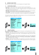
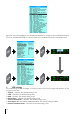
turned on or off through the Moving Map Menu – from the Moving Map press MENU, then select
TERRAINS, then choose between ON or OFF. Some things to note about Terrain Depiction:
• At scales under 1 nm, the Terrain is turned off, allowing for a clearer picture of Airport traffic
patterns.
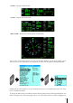
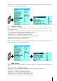
With Terrain On, the Quick Info function will display the approximate elevation in a “Pop-Up” bar
MENU
ENTE
R