
User manual

35
twice and select ‘Simulator’ from the Main Menu. Press ENTER, and set to “ON.”
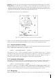
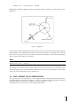
Once TAWS has been enabled, the EKP-IV will display a legend in the lower left corner of the
display that depicts the TAWS color scheme:
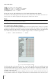
Fig. 3.5.11.2- TAWS
Please Note
When TAWS is enabled, the color scheme is always displayed. The rules for TAWS are divided into two levels:
1. L1=500 ft. agl / M1=1,000 ft. agl / H1=2,000 ft. agl
2. L2=1,000 ft. agl / M2=2,000 ft. agl / H2=3,000 ft. agl
The TAWS rules allow you to calculate the color scheme to be used for depicting the OCH: Obstacle Clearance
Height.
The OCH: Obstacle Clearance Height, is the difference of your own altitude (GPS Altitude) less
the Land Elevation:
OCH = ALT – LE
This calculation considers the Lowland and Highland definition, where:
A - Lowland is the terrain under 3,000 feet of elevation
B - Highland is the terrain over 3,000 feet of elevation
In the Lowland case, the TAWS colors will be red, yellow and green according to the following
values of the OCH:
§ Red: L1= from < 0 ft. up to 500 ft.
§ Yellow: M1= from </= 500 ft. up to 1,000 ft.
§ Green: H1= from </= 1,000 up to 2,000 ft.
§ Transparent (no color): > 2,000 ft.
In the Highland case, the TAWS colors will be red, yellow and green according to the following