
User manual

33
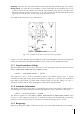
4. The minimum altitude of the leg
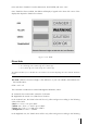
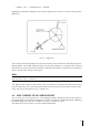
In the QUICK INFO window, you may get duplicate information about the same airway. This
duplicate data refers to two different legs. An example of where this may occur is when you
place the CURSOR in the proximity of a User Waypoint or Navigational Aid where the two legs
connect.
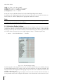
In order to view additional data regarding the selected airway; in the Map mode, press the ENTER
key once, select FULL INFO and press ENTER again to confirm, select ‘Enroute Airways’ and
confirm pressing ENTER.
Please Note
: The Enroute Airways information displayed in the FULL INFO page may present two
options:
1. Outbound = 0 designates the ending leg of the airway
2. Inbound = 0 designates the starting leg of the airway
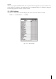
In the GOTO menu you can find:
1. SELECT AIRWAY: by selecting this item, you will display the ENTER AIRWAY window. Using the
cursor key, you can edit the Low Airway name.
Note
Once you confirm the selection with the ENTER key, the airway is depicted in black.
2. CLEAR AIRWAY
: selecting this item and pressing the ENTER key, the airway color will revert to
the original one.
Controlled Areas: ON/OFF. The default setting is On.
Restricted Areas: ON/OFF. The default setting is On.
FIR and UIR: ON/OFF. The default setting is Off.
MORA: ON/OFF. The default setting is Off.
3.5.10.3 Land Settings
The Land Settings menu controls the level of cartographic detail shown.
Roads: ON/OFF. The default setting is On.
Road Labels: OFF/AMERICAN/EUROPEAN. The default setting is American.
Railroads: ON/OFF. The default setting is On.
City Names: ON/OFF. The default setting is On.
Rivers & Lakes: ON/OFF. The default setting is On.
Cultural Features: ON/OFF. The default setting is On.
Natural Features: ON/OFF. The default setting is On.
Landmarks: ON/OFF. The default setting is Off.
3.5.10.4 Marine Settings
Bathymetric & Soundings: ON/OFF. The default setting is On.
Navigational Aids: ON/OFF. The default setting is On.
3.5.10.5 Other Settings
User Points: OFF/ICON/ICON LABEL. The default setting is Icon/Label.
Objects Overlap: ON/OFF. The default setting is On. When more then one object is at the same
position, the selection of On allows the screen to draw the objects overlapping.
LAT/LON Grid
: ON/OFF. The default setting is Off.
3.5.11 Terrains