
Operating instructions
Setting Up the HSI
600-00142-000 Rev 01 -27- Entegra EXP5000 PFD
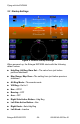
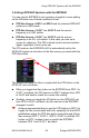
3.4 Setting Up the HSI
The Entegra EXP5000 can integrate with single or dual GNS 400/
500-series GPS or GPS/VHF navigator systems. When your
EXP5000 PFD is installed, it is configured for the number and type of
navigator systems on board.
Use the Nav button (Primary Nav) to select the navigator source for
the green single-line CDI and the moving map data. The active flight
plan from the selected navigator unit drives the moving map on the
HSI and will display up to 15 waypoints, including the curved
approach path and holding pattern segments.
GPS 1 is also the primary source for ground-speed readout and a
required element for the wind vector calculation and display. If GPS 1
is unavailable, ground speed and wind vector data are derived from
GPS 2. If the Nav source is selected to a VOR or localizer source, the
HSI will display the appropriate course deviation indicator. The
moving map from the associated GPS will still display.
For more information about the Wind Vector and the HSI moving map
display, see Magnetic Heading—A numeric indication of current
aircraft magnetic heading., on page 12. HSI moving map data is not
available on SRV aircraft.
Use the Bearing button to select the Nav source for the blue double-
line bearing pointer. If the selected bearing source is a Localizer, the
bearing pointer does not display.
To take full advantage of the EXP5000, GPS 2 can be loaded with
Direct-To waypoints, alternative flight plans, or Navaid frequencies to
provide additional guidance beyond what is loaded into GPS 1. This
information can be selected for display on the EXP5000 as the
Bearing or Aux.
While using the crossfill capability of dual-configured GPS systems is
fully supported and a common technique, it can prevent you from
taking full advantage of the multiple Nav source display capability of
the EXP5000.