
Technical data

Using Roadway Data for Finished Ground Surfaces
87
Key Concepts
■
If you want to import top surface points, datum points, or custom
point codes, then you must first define these points. From the
Cross Sections menu, choose Templates
➤
Edit Template, and then
reprocess the cross sections.
■
When you import top surface data or the datum data into the
drawing, both ditch and match slope points will be imported.
■
Point codes can include centerline points, ditch points, bench
points, catch points, and so on.
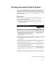
You can also create a 3D grid of the roadway by selecting Cross
Sections
➤
3D Grid. Then you can use the point information in that
grid for creating the finished ground surface. Process the grid data by
using the 3D Faces option. The following illustration shows a 3D grid
of a road.