
Technical data

Chapter 6 Viewing and Editing Roads in Section View
86
Using Roadway Data for Finished
Ground Surfaces
You can place points into a drawing that relate to a finished road
design. You can use these points as data for creating a finished ground
surface that contains the roadway data.
For example, you can create:
■
Existing ground, top surface, and datum template points
■
Points based on template point codes
■
Catch points and daylight lines
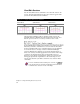
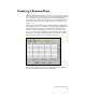
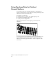
The following illustration shows template points inserted into
a drawing.
You can process this point data like any other point data and use it to
create a finished ground roadway surface. You can then paste this
surface into the existing ground surface to create a composite of the
two surfaces.