
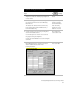
Technical data

Chapter 6 Viewing and Editing Roads in Section View
70
Overview of Viewing and Editing Roads in
Section View
After you have created an alignment and profile for a roadway, you
can generate cross sections. Cross sections are cut at stations along
an alignment.
Using the Cross Sections commands, you can:
■
Create existing ground cross sections for the alignment
■
Create finished ground roadway surface templates
■
Establish design parameters for ditches, superelevation,
and transitions
■
Extract, view, edit, and plot cross sections
■
Insert cross sections in a drawing for plotting
■
Output volumes using Average End Area or Prismoidal methods
■
Place design roadway points in a drawing or external file for
field staking
■
Create a 3D road grid of the alignment
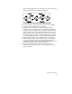
Creating Existing Ground Sections
Along a Road
After you have defined the horizontal alignment, you can extract and
plot cross sections of the existing ground data.
Key Concepts
■
You can extract cross section data from a terrain model or from a
station/offset/elevation text file.
■
You can plot sections that show existing ground conditions along
the roadway.
■
To create existing ground cross sections, you must define a road
alignment, but a profile is not required. The design profile is
required to apply a template to the sections.