
Technical data


Chapter 5 Viewing and Editing Roads in Profile View
64
To create an existing ground profile
Steps
Use
to look up
1 From the Alignments menu, choose Select
Current Alignment to make sure that the proper
alignment is set as current.
Make an
Alignment Current
2 Sample the existing ground data (either from a
terrain model surface, an ASCII text file, or
manual input) by using one of the commands in
the Profiles ➤ Existing Ground menu.
Overview of Sampling the
Existing Ground to Create
the Profile Data
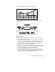
3 From the Profiles menu, choose Create
Profile ➤ Full Profile to draft the profile. The
profile can be drawn from either left to right or
right to left. You can also control the profile
datum, scale, and use of a grid.
You can draw the entire profile at one time or you
can import stages of the alignment.
Create a Complete Profile
4 You can add a grid to the profile any time after
the profile is drawn. To add a grid, from the
Profile menu, choose Create Profile ➤ Grid.
Draw a Grid on a Profile
Creating Finished Ground Road Profiles
After you create an existing ground profile, you can draw the
proposed finished ground profile elements, including the finished
ground centerline, offsets, and ditches and transitions.
The profile view of the roadway geometry is referred to as a “vertical
alignment.” Vertical alignments are composed of vertical tangents and
vertical curves.