
Technical data

Creating Existing Ground Profiles
63
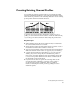
Creating Existing Ground Profiles
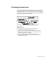
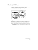
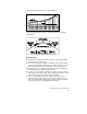
You can draft an existing ground profile in your drawing and then
add vertical alignment geometry to represent what the final roadway
will look like in profile view. The following illustration shows existing
ground profiles drawn in different directions.
To generate the station/elevation information required to plot a
profile, you can extract data from a surface or from an ASCII text file,
or you can type in station/elevation values using the profile editor.
Key Concepts
■
When sampling the profile from a surface model, be certain that
the correct surface model is set current.
■
Verify that the existing ground surface model is accurate. Create a
model that best reflects the conditions on the site.
■
You can set independent scales for horizontal and vertical features.
Make sure that the vertical scale is set properly for your drawing.
■
A profile has an invisible block attached to it to locate it in the
drawing. If you move the profile, first undefine the profile to
remove the old profile definition block, then redefine the profile
to create a new profile definition block. These commands are in
the Profiles
➤
Create Profile menu.
■
If you have more than one profile in a drawing, then use the
Set Current Profile command to select the correct profile to
use in subsequent profile commands. This is a graphical
method of selecting the current profile by picking a location
within the profile.