
Technical data

Chapter 5 Viewing and Editing Roads in Profile View
62
Overview of Viewing and Editing Roads in
Profile View
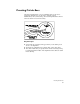
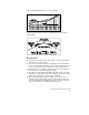
After you draft and define a horizontal alignment for a road, you can
create a road profile (also known as a vertical alignment or long
section) that represents the existing and finished grades along the
roadway centerline. To work in profile view, start by creating an
existing ground profile for a defined alignment by sampling elevation
data from a surface. You can then draft the existing ground profile in
the drawing, and draw the vertical alignments and vertical curves that
represent the finished ground profile design.
The finished ground profile commands are divided into the following
two sets of commands:
■
Finished ground centerline commands: use these commands for
drawing and defining the roadway centerline in profile view
■
Ditches and transitions commands: use these commands for
drawing and defining vertical offsets, such as ditches and transition
lanes
When you are drafting and defining vertical alignments, you must
select the command from the appropriate menu selection for the type
of vertical alignment you are creating.
After you draw a vertical alignment, you must define it as you do with
horizontal alignments. The finished ground elevations are used later
for calculating the elevations for the roadway cross sections.