
Technical data

Using the TR-55 Graphical Peak Discharge Method to Calculate Runoff
45
Using the TR-55 Graphical Peak Discharge
Method to Calculate Runoff
Technical Release 55 (TR-55), prepared by the Soil Conservation
Service (SCS), presents two simplified methods for estimating storm
water runoff from urbanizing watersheds. Although the procedures
found in TR-55 are particularly well suited to urban and urbanizing
watersheds, the methods can be applied, in general, to any small
watershed when the governing limitations of either method have
been adequately addressed.
The simpler of the two methods is the Graphical Peak Discharge
Method (GPDM). The Graphical Peak Discharge Method is intended
for use on hydrologically homogeneous watersheds for which land
use, soils, and cover type are uniformly distributed throughout the
watershed. The TR-55 Graphical Peak Discharge Method, as the name
of the method implies, determines the peak discharge only. If the
watershed in question is heterogeneous, or if hydrographs are
required, the TR-55 Tabular Hydrograph Method should be used.
NOTE
The Soil Conservation Service is now called Natural Resources
Conservation Service.
Key Concepts
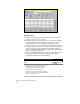
■
Determine the applicable rainfall distribution type, the size of the
drainage area, the runoff curve number (RCN), the time of
concentration (Tc), the size of the pond and swamp area, and the
amount of rainfall. This can all be calculated or selected using
commands from the Hydrology menu.
■
Slopes and elevations across a site can be extracted from a surface
model. You can also build a surface and model the watershed
before calculating runoff by using the AutoCAD Land Development
Desktop Terrain Model Explorer.
■
Refer to the SCS (Soil Conservation Service) TR-55 manual for more
information regarding the Graphical Peak Discharge Method,
particularly the implied limitations of the method.