
Technical data


Chapter 3 Performing Hydrologic Studies
36
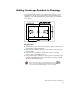
To add watershed and drainage data to your drawing
Steps
Use
to look up
1 Create an existing ground surface for the
proposed site.
Overview of Creating
Surfaces
2 Generate watershed data for the existing ground
surface model.
Create a Watershed Model
After Building the Surface
3 From the Terrain menu, choose Surface
Display ➤ Slope Arrows to draw arrows that
follow the slope of the existing surface.
4 From the Terrain menu, choose Surface
Utilities ➤ Water Drop to draw flow paths.
The Water Drop command traces the path of a
drop of water that lands on the point you pick in
the drawing to the point that it will outflow. This
can help you determine where the major outflow
points are and where you may need to add
culverts.
Draw Water Drop Paths
on the Current Surface
This data can help you visualize the slopes of a surface, where the
water will flow, and where the water will accumulate during a storm.
You can use this data to decide the best way of controlling the flow.
Now that you’ve visualized the runoff paths on your surface, you can
calculate the peak runoff flow for different storm events.
Using the Hydrology Calculators
Many of the features in the Hydrology menu use calculator-type
dialog boxes to solve for an unknown value. For each calculator, you
must enter the known values in the appropriate edit field for the
particular value, or use the corresponding Select button to pick the
value from the drawing or from another dialog box. You can select the
unknown value that you want to solve for from a popup list at the top
of the calculator. If you do not enter all values, then the calculation
will not be completed. An error message is displayed at the bottom of
the dialog box whenever you make an error entering data.