
Technical data

Creating Contours and Surface Data from a Grading Object
23
Creating Contours and Surface Data
from a Grading Object
If you want to use the grading object’s 3D information in a terrain
model surface, you have several options. You can create a new surface
from the grading object, you can create contours, or you can create
breakline data from the grading object for any new or existing surface.
Surfaces are created using 3D information from the grading object
footprint, daylight lines, and projection lines. The footprint and
projection lines are treated as breaklines. The daylight line is treated
as a boundary. After you have created the surface it has the same
functions as other surfaces, and you can manage the surface from
within the Terrain Model Explorer.
Using the Create Contours command, you can directly create contours
from a grading object without having to first create a terrain model
surface. When you use the Create Contours command a temporary
surface is created using the daylight line as the surface boundary. The
contours are generated from this temporary surface and then the
surface is discarded.
Breaklines can be created from a grading object and added to the
current surface, to a new surface, or to any existing surface. When you
create breaklines from a grading object, the breakline information is
determined from the grading object footprint, daylight lines, and
projection lines.
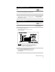
To create a surface from a grading object
Steps
Use
to look up
1 Create a grading object.
For more information, see “Creating a Grading
Object” in this chapter.
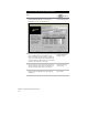
2 From the Grading menu, choose Slope
Grading ➤ Create Surface to display the New
Surface dialog box.
Create a Surface from a
Grading Object
3 Type a name and an optional description for
the surface and click OK. The surface is created
and built.