
Technical data

Chapter 2 Getting Started with AutoCAD Land Development Desktop
70
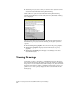
To select the coordinate zone for a drawing
Steps
Use
to look up
1
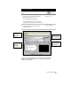
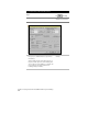
From the Projects menu, choose Drawing Setup.
Change the Current Zone for
a Drawing
2
Click the Zone tab.
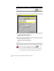
3
From the Categories list, select the geodetic zone
category you want to choose a zone from.
Categories include Lat/Longs, different countries,
and different states in the United States.
4
Select a zone by clicking on it. The zone details are
listed in the lower half of the dialog box.
If you don’t want to base the drawing on a
coordinate zone, then leave the CS Code box
blank.
5
Click OK.
For more information about setting up drawings, use to look up
“Overview of Setting Up Drawings” in the online Help.
For more information about performing coordinate zone transformations,
see “Working with Points” in Chapter 3 “Working with COGO Points.”