
Technical data

Working with Projects
59
Using the World Coordinate System for
Creating Data
When you begin a new drawing in AutoCAD Land Development
Desktop using one of the default drawing templates, you are
automatically in the World Coordinate System (WCS); the X axis is
horizontal, the Y axis is vertical, and the Z axis is perpendicular to the
XY plane.
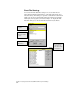
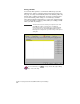
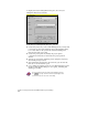
When you are in the WCS, the AutoCAD UCS icon displayed at the
lower-left corner of the graphics screen looks like this:
If the coordinate system is set to anything other than World, the W
disappears.
If the coordinate system is set to anything other than World when
you create data in AutoCAD Land Development Desktop, that data
will NOT be processed correctly.
To change the coordinate system to World, you can type UCS on the
command line, and then type World.
WARNING!
When you are creating data with AutoCAD Land Development
Desktop, it is very important that the coordinate system be set to
world (WCS).
Working with Projects
Each AutoCAD Land Development Desktop drawing must be
associated with a project. This section describes in more detail the
function of projects and how to manage them.
■
Projects are required if you want to work with AutoCAD Land
Development Desktop commands. However, you can run AutoCAD
or AutoCAD Map command without having a project selected.
“W” indicates that the
coordinate system is
set to world