
Technical data

How to Use the Documentation Set
21
Design Documents
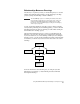
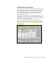
After your project is completed, you can create final labels and plot
the drawing. If your project is based on AutoCAD Map you can
configure the plotter to print the maps in tiles. You can also create
legends for the maps that you print. Using Autodesk Civil Design, you
can also create automated plan/profile and section sheets for road
alignments and profiles with the Sheet Manager commands.
To annotate a drawing, you can label Coordinate Geometry features
such as lines, curves, spirals, and points. If desired, you can create
tables in a drawing that list the details of the geometry.
You can label geometry with either dynamic or static labels. Dynamic
labels are automatically updated if the objects or the label styles
change—this is a big time-saver because you do not need to manually
update each label if the drawing objects are edited or if the label style
changes.
Other labeling options include alignment station labels and contour
labels.
For more information about working with AutoCAD Land
Development Desktop, see Chapter 2, “Getting Started with
AutoCAD Land Development Desktop.”
How to Use the Documentation Set
The documentation set for AutoCAD Land Development Desktop
includes both online Help files and printed documentation. Because
AutoCAD Land Development Desktop combines the technology of
AutoCAD and AutoCAD Map along with the Land Desktop features,
the online AutoCAD and AutoCAD Map documentation is also
included in the documentation set.
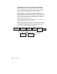
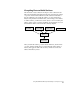
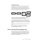
Drawing 1
Create Labels
Plot a Map
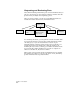
Book
Create
Thematic
Maps and
Legends
Plot