
Technical data


Chapter 8 AutoCAD Map and AutoCAD Land Development Desktop
276
To create an overlay topology (
continued
)
Steps
Use
to look up
13
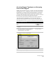
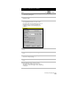
Under Result Topology, specify a name,
description, and layer for the resulting topology.
Result Topology area
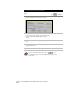
14
Click Proceed to create the overlay topology.
For more information about topologies, use to look up “Overlay
Two Topologies” in the online Help.
Plotting Maps
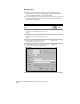
To plot maps, you must create a plot map set. This set contains all the
information you need to plot a map or a series of maps. This set
includes a plot query, map boundary definitions, and a plot layout
block.
NOTE This topic describes the plotting options for only the AutoCAD Map
commands, not for the entire AutoCAD Land Development Desktop
program.
To plot using the AutoCAD Map plotting commands, you must
■
Create a Map project, attach the map drawings that you want to
plot, and then query the objects in those drawings. You can
execute this query in preview mode.
■
Create a drawing that contains the map boundary definitions. You
can draw a boundary definition as a closed polyline. For example,
to create map tiles, create a new drawing, and then draw a polyline
for each tile of the map. You can attach the map and do a preview
query to see where to draw the boundaries. Each boundary must
have a name. To create a name, create a data table and attach
object data to the boundary polylines.
■
Create a plot layout block. This block defines how each plot in the
plot set is laid out. This block must contain at least one floating
viewport.
For more information about plotting map sets, use to look up
“About Plotting” in the online Help.