
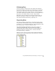
Technical data

Chapter 1 Introduction
20
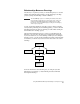
Outputting and Evaluating Data
AutoCAD Land Development Desktop has several commands that you
can use to list and report object data for evaluation. Surfaces have the
greatest variety of analysis and outputting options.
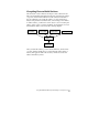
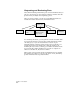
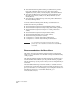
After you create a surface, you can use several different methods to
evaluate the surface that is created, as illustrated below.
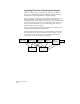
For evaluating the surface, you can generate contours and label them.
You can create quick cross sections and profiles that display in their
own dialog box, or you can create final cross sections to plot.
Watershed models, waterdrop trails, and slope arrows can help you
evaluate the need for site runoff control. The 3D viewing tools,
including the object viewer, can help you visualize the surface in 3D.
You can perform volume calculations if you want to compare two
surfaces to calculate cut, fill, and net volumes.
Other output options include parcel and alignment reports, tracking
the elevation of a surface as you pass your cursor over it, and listing
geodetic information about points and lines.
Surface TIN
Contours
Cross Sections
Profiles
Watershed Models
Waterdrop Trails
Slope Arrows
3D Viewing
Volume
Calculations