
Technical data
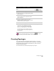

Creating Topologies
269
To perform zone conversions (
continued
)
Steps
Use
to look up
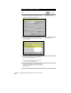
7
Choose the source drawing, and then click Add.
8
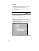
Click OK to return to the Assign Global Coordinate
System dialog box.
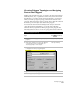
9
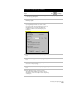
Under Source Drawings, click Select Coordinate
System to display the Select Global Coordinate
System dialog box.
10
Select the coordinate system of the source
drawing and then click OK to return to the Assign
Global Coordinate System dialog box.
11
Click OK to close the dialog box.
12
Define and execute a query that will bring the
objects in the source drawing into the Map
project. For more information about defining
queries, see “Defining Queries” in this chapter.
The objects from the source drawing convert to
the new coordinate zone as they are queried into
the Map project.
Define a Query
For more information about zone conversions, use to look up
“About Projections and Coordinates” in the online Help.
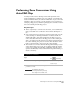
Creating Topologies
A topology shows the relationships between objects. A topology
describes how lines and polygons connect and relate to each other,
and forms the basis for advanced GIS functions, such as network
tracing and spatial analysis.
You can create node, network, and polygon topologies.