
Technical data

Chapter 8 AutoCAD Map and AutoCAD Land Development Desktop
268
To perform zone conversions (
continued
)
Steps
Use
to look up
3
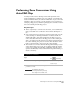
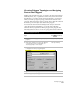
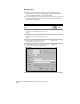
From the Map menu, choose Tools ➤ Assign
Global Coordinate System
to display the Assign
Global Coordinate System dialog box.
Assign a Coordinate System
to a Drawing or Project
4
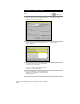
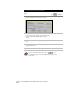
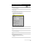
Under Active Project, click Select Coordinate
System to display the Select Global Coordinate
System dialog box.
Select Global Coordinate
System dialog box
5
Select the coordinate system that you want to
use and click OK to return to the Assign Global
Coordinate System dialog box.
This is the coordinate system that you want to
convert your existing drawing(s) to.
6
Under Source Drawings, click Select Drawings to
display the Select Drawings to Assign Coordinate
System dialog box.