
Technical data

Using AutoCAD Land Development Desktop to Complete a Project
19
Compiling Data to Build Surfaces
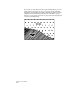
The end result of data collection and input is often a surface model
like a TIN (Triangulated Irregular Network) that represents the surface
of a parcel of land in three dimensions. This surface is invaluable to
anyone evaluating a site. From this surface, you can perform slope
analysis and generate watershed models, contour maps, and volumes.
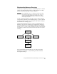
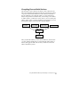
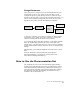
To build a surface, you must choose the objects to use for creating the
surface, such as points, contours, breaklines, and boundaries. You can
then build the surface as shown in the following diagram.
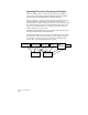
After you build the surface, you can edit the TIN lines, add new lines
or points, and flip triangle faces. You can build the surface again, if
needed, and apply the same edits as before, which are saved to the
surface’s Edit History folder.
Point Data Contour Data Breakline Data
Build
Surface TIN
Boundary Data