
Technical data

Chapter 1 Introduction
18
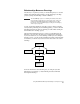
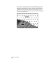
If you want to create maps that show spatial relationships, you can
define regions and objects as parts of topologies. In the following
illustration, the alignment is actually a dividing boundary between
buildable land and wetlands. Using the AutoCAD Map topology
features, you can assign object data to polygonal areas and query the
total area of buildable land.