
Technical data

Chapter 8 AutoCAD Map and AutoCAD Land Development Desktop
254
To save back objects to the source drawing (
continued
)
Steps
Use
to look up
9
Click Yes to add the object you just edited to the
Save Set.
You see the message, “1 object(s) added to
save set.”
10
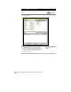
From the File menu, choose Save.
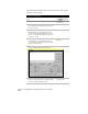
The Save Objects to Source Drawings dialog box is
displayed.
11
Click OK to save the objects back to the source
drawings.
For more information about saving, use to look up “About Save
Options” in the online Help.
Inserting Geo-Referenced Images
You can use the Insert command on the Map ➤ Image menu to insert
geo-referenced images into your drawing. Geo-referenced images are
images that are saved with real-world coordinates. These coordinates
can be used as a correlation source when you insert the image into a
drawing. Correlation controls the location, scale, and rotation of the
image.
Key Concepts
■
Some images, like GeoTIFFs, store correlation within the image file
itself, so you can choose Image File as the correlation source.
■
Other image types are saved with world files that store the
correlation information, and if a world file was saved for the image,
you can select the world file as the correlation source.