
Technical data

Map Projects and Drawing Sets
243
Map Projects and Drawing Sets
When you use the Map commands, you can work with your drawings
in two different ways. Sometimes you open .dwg files directly and
work on them. Other times you can attach other drawings to the Map
project to create a drawing set. Then you can query objects from the
drawing set into the Map project.
NOTE In AutoCAD Map, the current drawing is referred to as a project. To
avoid confusion between drawings and the AutoCAD Land
Development Desktop project system, this documentation uses the
term Map project to refer to the current AutoCAD Map drawing.
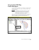
When you work with a drawing set, you can view and edit the objects
in more than one drawing at a time by performing queries. For
example, you can define a query that inserts all objects in the source
drawings that are on layer WATER into the Map project.
When to Create Drawing Sets
If you want to perform an action that requires information from other
drawings, then create a new drawing and attach source drawings to
create a drawing set. You must use drawing sets if you do any of the
following:
■
Perform queries from other drawings or databases
■
Work with drawings that were created using different coordinate
zones
■
Edit objects that are in source drawings
■
Plot map sets
If you want to perform an action that does not need objects in any
other drawing, then use the Open command on the File menu to
open that drawing. You cannot work in a drawing set when you do
any of the following:
■
Add object data to the drawing objects
■
Digitize
■
Clean up maps
■
Create topologies (except overlay topologies)