
Technical data

Using AutoCAD Land Development Desktop to Complete a Project
15
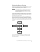
Relationships Between Drawings
Another way to organize your data, on the drawing-level, is to use the
built-in AutoCAD Map functionality to attach drawings to the Map
project by using AutoCAD Map’s Attach command.
NOTE The AutoCAD Map “project” is a drawing file that lists and controls
the items that are defined for the current work session. It does not
manage the AutoCAD Land Development Desktop project data
based on the current Land Desktop project that you are working in,
and is not project-specific.
A group of drawings attached to the Map project is called a drawing
set. By creating a drawing set and running queries, you can work with
information from more than one drawing at a time while viewing all
the information in the Map project.
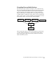
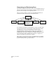
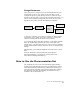
The following diagram shows how you can copy information from
Drawings 1, 2, and 3 into the Map project using queries. Drawings 1,
2, and 3 are referred to as source drawings. When you are working in
the Map project, you can use the information from the other drawings
as references, or edit the objects and save the edits back to the source
drawings.
For more information about drawing sets, see “Map Projects and
Drawing Sets” in Chapter 8, “AutoCAD Map and AutoCAD Land
Development Desktop.”
Project Files
Drawing 1
Drawing 2
Drawing 3
Query
Map Project
Drawing