
Technical data

Chapter 6 Creating Cadastral Information
222
If you use polylines to draw parcel geometry, then you must break
crossing polylines before defining the parcels. Also, delete any
duplicate lines that you may have drawn where two parcels abut each
other. You can break crossing lines and erase duplicate lines by using
the AutoCAD Map Cleanup command. For more information, see
“Cleaning Up Maps” in Chapter 8, “AutoCAD Map and AutoCAD
Land Development Desktop.”
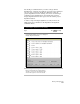
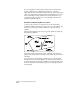
Draw Parcel Geometry Based on Area
To draw a parcel so that it is a specific area, use the Parcel Sizing
commands. Simply draw the parcel with only one open segment, and
then use one of the parcel sizing commands to draw the closing
segment.
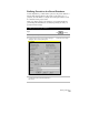
The following illustration shows how a parcel is defined by using the
Slide Bearing command.
Depending on the parcel settings, these commands can define the
parcel to the parcel database, and they can also label the parcel that is
calculated.
You cannot use the Parcel Sizing commands to edit a parcel that is
already defined to the parcel database. To change a parcel definition,
you must delete the existing parcel definition and redefine the parcel.
For more information about deleting parcels, see “Managing Parcels”
in this chapter.