
Technical data


Chapter 6 Creating Cadastral Information
208
Introduction
You can draft horizontal alignments and parcels at any time during
the project process. The project does not need existing surfaces before
you create alignments or parcels.
You begin by drawing simple objects, like lines, curves, spirals, or
polylines to represent the geometry of the alignment or parcel. You
then define the alignment or parcel to a database. All the data is
stored in an external database, so all drawings in the project can access
that data.
Because of the external database, you do not need to draft the
alignments or parcels in the drawing in order to reference them. After
defining them, you can delete the objects from the drawing if desired.
Then, if you must visually reference the alignments or parcels, you
can import them into the drawing.
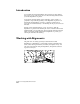
Working with Alignments
The plan view of roadway geometry is called the horizontal
alignment. For alignments, you can define roadway centerlines and
create offsets that represent lanes, shoulders, and rights-of-way. You
can create station labels along the alignment, and generate stakeout
reports for surveyors.