
Technical data

Chapter 5 Working with Surfaces
206
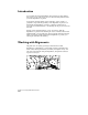
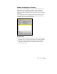
Projecting 2D Lines onto a 3D Grid
You can project 2D objects such as lines, curves, and polylines from a
flat drawing plane onto a 3D surface grid. This is an effective way to
present information such as a road location, building outline, or
property boundary.
Key Concepts
■
You can project lines, curves, and polylines onto the grid.
■
The objects are drawn on a separate layer.
■
For a smoother site, set the number of “facets” per grid face to a
higher number.
■
If the site contains details such as walls or curbs, you should use the
3D Faces command on the Terrain
➤
Surface Display menu. This
option imports all the surface triangles as 3D faces. All surface
details show up on the imported faces.
To project objects onto a grid
Steps
Use
to look up
1
Select the current surface.
Make a Surface Current
2
Make sure you are working in plan view.
PLAN Command
3
From the Terrain menu, choose Surface
Display
➤
Grid of 3D Faces to create a grid of 3D
faces. You have complete control over grid
location, size, vertical exaggeration, and facets
per grid face.
Create a Surface Grid of
3D Faces
4
Select all lines, curves, and polylines that to be
projected, and specify a layer to draw them on.
5
To view the site in 3D, use either the DVIEW or
VPOINT command, or use the Object Viewer
from the Utilities menu.
DVIEW Command
VPOINT Command
Use the Object Viewer