
Technical data
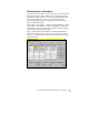

Using AutoCAD Land Development Desktop to Complete a Project
13
Collecting Data
Points are the most common form of data. While AutoCAD Land
Development Desktop cannot help you collect data, it provides easy
ways for you to import and create points in the drawing. Autodesk
Survey has the data collector support built in, as well as support for
our standard .fbk (fieldbook) format. Points are saved automatically to
the project point database when you create or import them.
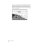
Other data sources can include contour maps and raster images. To
make this data useful, you may need to digitize it with one of the
AutoCAD Land Development Desktop digitizing tools.
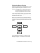
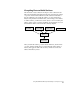
Organizing Data
AutoCAD Land Development Desktop is structured around projects.
You create AutoCAD .dwg files, as well as create and maintain many
project files stored outside the drawing files. This management system
allows many people to share the same project data.
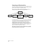
AutoCAD Land Development Desktop uses projects to help you
organize all the drawing files, support data files, and settings
associated with each job that you work on. You must assign every
drawing you create to a project in order to run AutoCAD Land
Development Desktop commands.
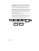
When you create a project, a folder is created in Windows Explorer
under the project folder. Database files and drawings are stored here.