
Technical data

Working with Surface Output and Visualization Tools
201
To contour around a pond by using a surface boundary (
continued
)
Steps
Use
to look up
8
Press ENTER at the Select polyline for boundary
prompt to end the command.
The vertices on the boundary are added to the
triangulation. The elevations for the breakline are
retrieved from the surface model.
9
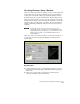
Use the Create Contours command on the Terrain
menu to create contours from the surface. As the
contours are generated, you can see that they are
not drafted within the polygonal boundary.
Create Contours From a
Surface
Comparing Two Surfaces to Calculate
Volumes
You can calculate volumes or depths between surfaces by comparing
them. For example, you may want to compare existing ground surface
data with as-built data. Or, if you have borehole data, then you may
want to calculate the volumes that exist between the top surface and
rock, for example.
AutoCAD Land Development Desktop includes three volume
calculation methods:
■
Grid method: Based on a grid that compares elevational
information between the first and second surface. This method
creates a volume surface.
■
Composite method: Creates a volume surface that includes all the
surface points from the first and second surface. The Z values in the
new surface are the elevational difference between the first and
second surface.
■
Section method: Calculates volumes based on sampled cross
sections.
You can also calculate parcel volumes, which are based on parcels that
exist within the larger site.
In all cases, you need two surface models. From these two surfaces,
you must define a stratum, which specifies which two surfaces are
used in volume calculations. Before you can calculate volumes, you
also need to define a site, which represents the area of the stratum
that you want to calculate volumes for.