
Technical data

Chapter 5 Working with Surfaces
196
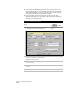
To view a section of a surface (
continued
)
Steps
Use
to look up
6
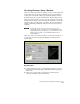
To display a different section view, you can move
an existing section line using grips.
Click a section line to display the grips, select a
grip, and then move it to a new location to edit
the section line. The section in the window is
updated automatically.
Grip Edit Quick Section Lines
Creating Contours
Contours make it easy to recognize the elevational values of a surface
at a glance. You can use AutoCAD Land Development Desktop to
create existing ground or finished ground contours. To create
contours, you can:
Generate contours from the
current surface model.
Convert polylines to
contours.
Vectorize contours on a raster
image, and then convert the
polylines to contours.
Digitize a paper contour
map.
Copy contours.
Offset contours.
NOTE Contours can be used to represent features other than elevations.
For example, they can represent rainfall intensity, soil contamination
lines, and so on.