
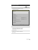
Technical data


Chapter 5 Working with Surfaces
194
Key Concepts
■
The surfaces does not need to be drafted in the drawing to obtain
elevational information from it.
■
Make sure that the proper surface is set as current.
■
The elevation values are displayed in the status bar at the bottom of
the screen.
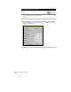
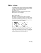
To dynamically display surface elevations
Steps
Use
to look up
1
From the Terrain menu, choose
Set Current Surface
to make the desired surface model current.
Make a Surface Current
2
From the Inquiry menu, choose Track Elevations.
Track Elevations
3
As you move the pointing device to a point, the
elevation at that point is displayed on the status bar.
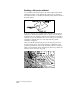
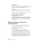
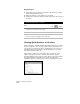
Viewing Quick Sections of a Surface
When you need to examine the elevational characteristics of a surface
along a straight line, you can create quick sections and profiles. You
can use these sections and profiles as visualization tools to help you
determine where you may need to modify the surface, or to review
the elevational relief of the site.
Each section is defined by a section line that you draw across the
surface. Selecting two points to draw the line creates a section.
Selecting multiple points creates a profile. These sections and profiles
are displayed in their own window on screen. The following
illustration shows a profile that was created by selecting three points.